The recently-uncovered truth about crossing a freezing cold glacial river is: it’s best done with your pants off.
We can learn a lot from highly experienced Alaska mountaineers, and I’m confident this is the single most important tip for better technique in the mountains. So pay attention.
A well-executed pants-off crossing requires:
1. Confidence. Trust yourself and your ability to successfully make the crossing without pants. If you fall and bumper-butt downstream, it will be terrible, but try not to think about it.
2. Speed. Like in the alpine, the faster the better. Remove your pants as quickly as possible. Similarly, upon reaching the opposite bank, put your pants on as quickly as possible.
3. Composure. If, and more likely when, the frigid water splashes your genitalia, breathe deeply, observe the sensations, but do not show any outward sign of discomfort. For example, don’t yell, “OH ICE BALLS, THAT’S COLD!”
After Ice Fest on the Matanuska glacier (in mid-September), Cory and I set aside two days for ascending a peak to the east. He chose an objective and sent me a topo the week before. As we left his truck, I asked him if anyone had been to the top before. He said, “Nope. Steve Gruhn didn’t think so.” (Steve is Alaska’s mountain trivia master. Don’t bother with Google; he has memorized everything there, too.)
When we reached the river a few hundred yards below the toe of the glacier, Cory told me he was taking his pants off. I had never taken my pants off for a river crossing before, but I followed Cory’s leadership and chose to do the same.
While I fumbled with my shoelaces, Cory already had his pants off and began trudging across. Whether the just-turned-to-liquid-water propelled him like a jet boat or he was simply skilled at placing his feet in the crevices between boulders he couldn’t see, he arrived at the other side in notable time. Though he soaked his boxers, never did I see him grimace and shout, “OH ICE BALLS, THAT’S COLD!”
 |
| My first pants-off river crossing, just below the Matanuska glacier. |
Our bodies warmed walking over some hills, across a beaver pond, and up the valley. Unfortunately, Glacier Creek pinched off the gravel bar and forced us to either enter thick brush or cross the frigid water. Cory muttered something about how the river had changed—he didn’t remember needing to cross again—as he whipped off his shoes and pants, and crossed with his boxers strapped to his pack.
Like when staring up at the intimidating crux pitch on a long, committing route, I passed the sharp end to Cory and chose to keep my pants on.
Again and again, five more times, he stripped off his socks and shoes, slid off his pants, refastened his socks and shoes, and crossed with confidence and composure. Meanwhile, I ambled across the frigid waters, stood still for a minute to drain my shoes, and BOOM he was marching onwards beside me! These transitions were so fast I wondered—and still wonder but haven’t mustered the courage—better to just let him read this here—if he once had a career as a pants-off artist.
Almost as surprising as Cory’s pantics was the presence of gigantic tire tracks that meandered up the valley. I studied their width (at least two feet), the distance between them (far more than any vehicle I’ve ridden in), the tread pattern (no doubt industrial), and the remarkable turning radius. The turning radius baffled me most. How could something so huge turn so tightly and also ford the river every 500 feet? And did the operator(s) have their pants on?
We spent a comfortable night in a tent at 2000 feet elevation and departed around 7:00 AM the next morning. Soon, we stumbled upon the mysterious vehicle, of which type I hadn’t seen since my youth exploring Maine’s North Woods. A skidder. Though designed for pulling trees off steep hillsides, this skidder appeared to be here for carrying moose out of the valley. Would they put the beast in a bag and hoist it or would they clamp onto it with the massive “grapple?!”
 |
| Cory Hinds and the mysterious tire tracks. |
 |
| This is what a skidder looks like. |
The actual hiking of Peak 7700 was straightforward and, I imagine, about as pleasant as it gets for a first ascent in 2016. Enjoying views from both sides, we followed a ridge into the snow, post-holing more than expected, and stopping to eat snacks and to chat. Our paces slowed considerably around 7000 feet, when we felt the altitude. Then we were at the summit. It was sunny and there was no wind! Via a snowy gully and beautiful side-hilling to the north, we were back in camp around 7:00 PM.
Mountains usually get better—bigger, taller, steeper, more covered in snow and ice—closer to the center of a range. In addition to the opportunity to practice pants-off glacier river crossings, the lovely part about Peak 7700 is it provides stunning, big mountain views while only nine miles from the road as the crow flies, and the hike is entirely non-technical. Why on earth didn’t anyone go up this before?!
 |
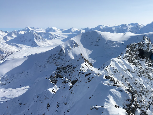
| View from the summit of Peak 7700. Matanuska glacier at left. Lots of ice on top of the peaks in the distance. |
 |
| Route map |

0 comments:
Post a Comment